Poster · Ukrainian People’s Republic · 1919 · Ukrainian War of Independence
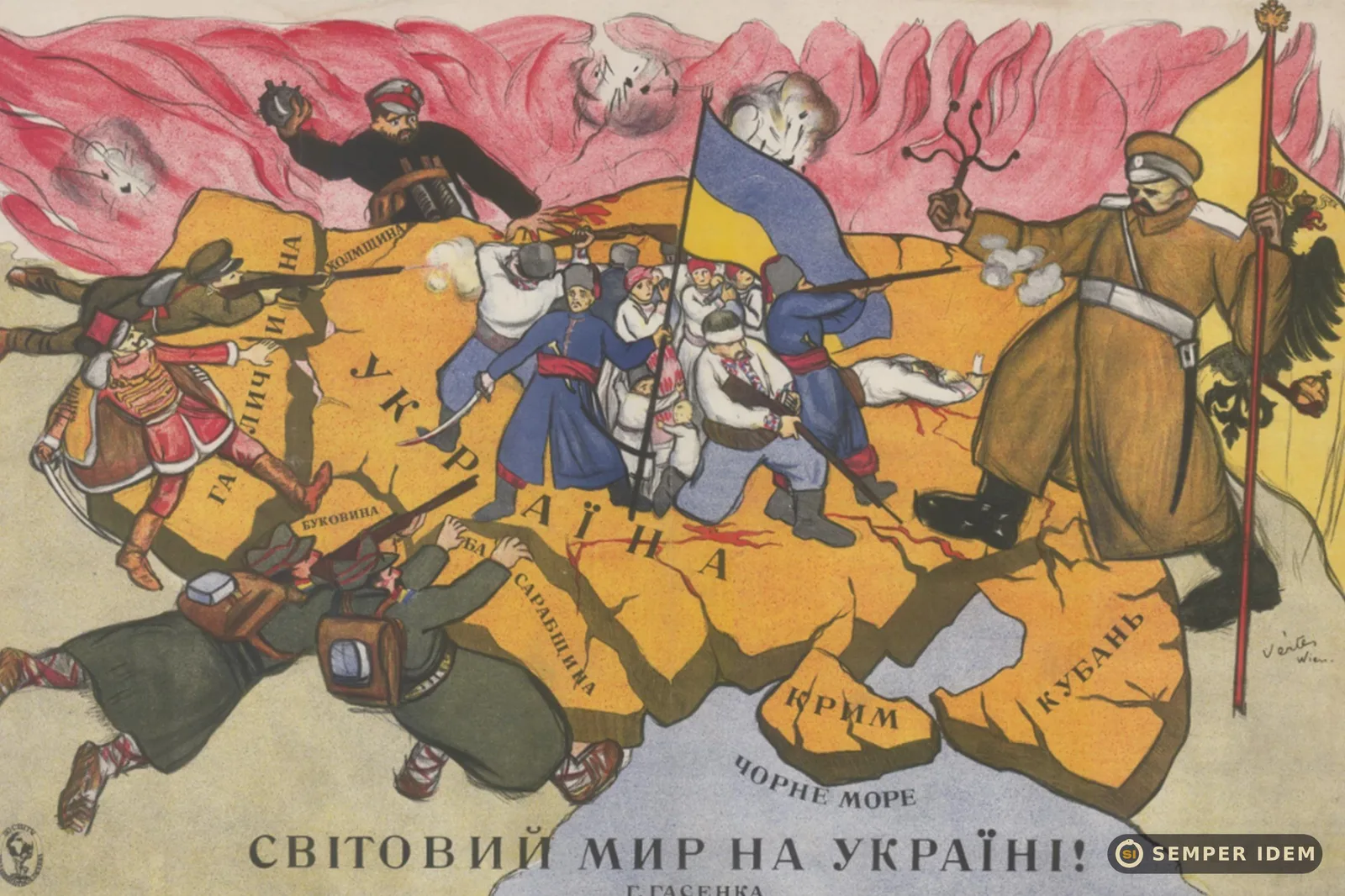
World Peace in Ukraine!
Original: «Світовий мир на Україні!»
In 1919 the world was talking about peace. Ukraine was fighting on every border.
- Themes
The poster, in Ukrainian, is a map. It shows Ukraine as its leaders imagined it at the time: with Galicia, Kholm, Bukovyna, Bessarabia, Crimea and the Kuban. In the centre, Cossacks under a blue-and-yellow flag hold the line. Attackers close in from every side: from the east a White Guard soldier with the imperial eagle, from the north a Bolshevik with a bomb, from the west a Polish soldier and a Hungarian in a red hussar uniform, from the south-west Romanian troops. The title is bitterly ironic: “World Peace in Ukraine!”
1919 was the year of the Paris Peace Conference, where the great powers redrew the map of Europe. For Ukraine it was a year of war on several fronts at once, and its delegation in Paris was effectively ignored. The poster was printed in Vienna, then one of the hubs of Ukrainian diplomacy and emigration. Hasenko worked in the UPR’s missions abroad doing exactly this: making the Ukrainian case in the foreign press and producing maps of Ukrainian lands. Vertès, who later found fame in Paris and Hollywood, was in Vienna as an émigré after the fall of the Hungarian Soviet Republic.
The device is the map as argument. It shows what a united Ukrainian state should look like and explains why it does not exist: there is an attacker on every border. The irony of the title is aimed at a European rhetoric of peace that did not notice the war.
The most important part of the map is the east and the north. The White Guard and the Red Bolshevik were fighting each other, yet they marched on Ukraine together. The Whites fought for a “one and indivisible” Russia, the Reds for Moscow’s rule in Soviet wrapping; neither recognised an independent Ukraine. There was no “good Russia” for Ukrainians then.
Semper Idem · today’s parallel
Today Europe is again talking about “peace” while missiles fall on Ukrainian cities. And the illusion lives on that there is another Russia that will leave Ukraine alone. The 1919 poster answers that plainly. Poland and Romania, shown among the attackers alongside Hungary, are today Ukraine’s allies: that part of the map belongs to history.
Context
Ukrainian People’s Republic, Vienna, 1919 or 1920. Concept: Heorhiy (Yuriy) Hasenko (1894–1933), UPR diplomat; drawing: Marcel Vertès (1895–1961). Printed by Christoph Reisser’s Söhne, Vienna.
Map of Ukraine including Galicia, Kholm, Bukovyna, Bessarabia, Crimea and the Kuban. Cossacks with a blue-and-yellow flag in the centre; attacked by a White Guard soldier, a Bolshevik, a Polish soldier, a Hungarian hussar and Romanian troops.
Copy: Slavonic Library, Prague.
Sources
- Slovanská knihovna, Praha
- Wikimedia Commons
- Енциклопедія сучасної України, «Гасенко Георг» (in Ukrainian)
- Радіо Свобода (2017) (in Ukrainian)
- Енциклопедія сучасної України, «Версальський мирний договір» (in Ukrainian)